Updated 15th December - Covering 22nd Dec 2025 - 13th Jan 2026
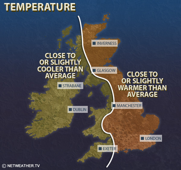
Mean temperatures are expected to be about 1C above the 1991-2020 long-term normal in eastern Scotland and north-east England, but 1 to 2C below in parts of southern, especially south-western England, and probably parts of Wales and western Scotland.
It is forecast to be drier than normal, especially in the west, which will be in stark contrast to the past few weeks. Precipitation totals will be nearer normal in eastern counties, especially near North Sea coasts, but probably still generally below normal.
Sunshine totals are expected to be below normal overall in eastern England, but above normal in most western areas, especially western Scotland and north-west England, and in Cornwall.
High pressure is expected to dominate the weather during this week. Highest pressure looks likely to be to the north of Britain early in the week, bringing a generally easterly flow, but because continental Europe will be mild for the time of year, temperatures will be near or slightly above the seasonal norm. It will tend to be cloudy for much of the country with some light, showery rain especially in the east, but sheltered western areas, especially in western Scotland, can expect some sunny periods and colder nights with potential for some frost. The high pressure will tend to extent across more of the country as the week progresses, resulting in more of the country, especially in the west, having sunny spells by day and some frost and patchy fog at night. However, a generally north-easterly flow is likely to maintain predominantly cloudy weather in eastern Britain, especially eastern England, with some showery light rain or drizzle near eastern coasts at times.
Relative to the 1991-2020 long-term normal, temperatures during this week are forecast to be 1 to 2C above normal in eastern Scotland and north-east England, especially due to high night time minima. However, they will probably be near to slightly below normal in most western and southern parts of Britain, and in parts of southern England, especially the south-west, they may be 1 to 2C below normal.
It will be drier than normal in all parts of the country, but some North Sea coastal areas may end up with up to half the normal precipitation amount from light showers coming in off the North Sea. Many western areas will probably stay completely dry.
Sunshine totals are expected to be above normal in most parts of western Scotland, north-west England, Northern Ireland, west Wales and south-west England, but below normal near the east coast of Scotland and in eastern England.
High pressure is again forecast to dominate during this week, but continental Europe is forecast to have cooled down considerably with the lack of a strong south-westerly powering in off the North Atlantic. As a result, any easterlies are more likely to be cold and potential sources of wintry precipitation, especially in eastern parts of England. While there may be snow events during this week, the emphasis is expected to be predominantly on dry and cold weather. Towards the end of the week, we may see high pressure move more to the west and north-west of Britain, pulling winds in from the north. Temperatures are likely to be slightly above normal in northern and eastern Scotland and north-east England, but probably 1-2C below normal in most western and southern regions of Britain. Sunshine is again likely to be above normal in most western parts of the UK but below normal in the east, especially near North Sea coasts, and it is expected to be drier than normal, especially in the west and north-west of Britain.
This period has potential to feature significant wintry weather for a time, especially in the north and east, with high pressure moving to the west and north-west and bringing northerly winds, which have potential to deliver wintry showers to the north and east and some longer outbreaks of precipitation at times, which has potential to fall as snow for some. As the high moves further out to the west, it may turn milder towards the end of the period with winds becoming more predominantly westerly. Overall, temperatures are likely to be near or below normal during this period, probably about 1C below taking the UK as a whole. It is likely to continue drier than average in the west, but with nearer average precipitation more likely in the east and south of Britain. Sunshine will probably be above normal for most, especially in the west and north-west.
Monthly weather forecast
The month ahead forecast is written by Ian Simpson and is updated every Monday.