


Yes, it's been very wet but it doesn't take much for vegetation to dry out as the UK temperatures rise and the wildfire risk returns. Models can highlight areas of concern.
After all the rain over recent months, the waterlogged fields and lingering standing water it may seem odd to be considering wildfire risk. And yet as more sunshine warms the air and spring progresses, maybe it's the best time.
"So far we've had 29 wildfires reported to the Fire Resilience Reporting Tool this year across England and Wales, despite all the wet weather." D.Swallow Group Commander Hereford & Worcester Fire & Rescue.
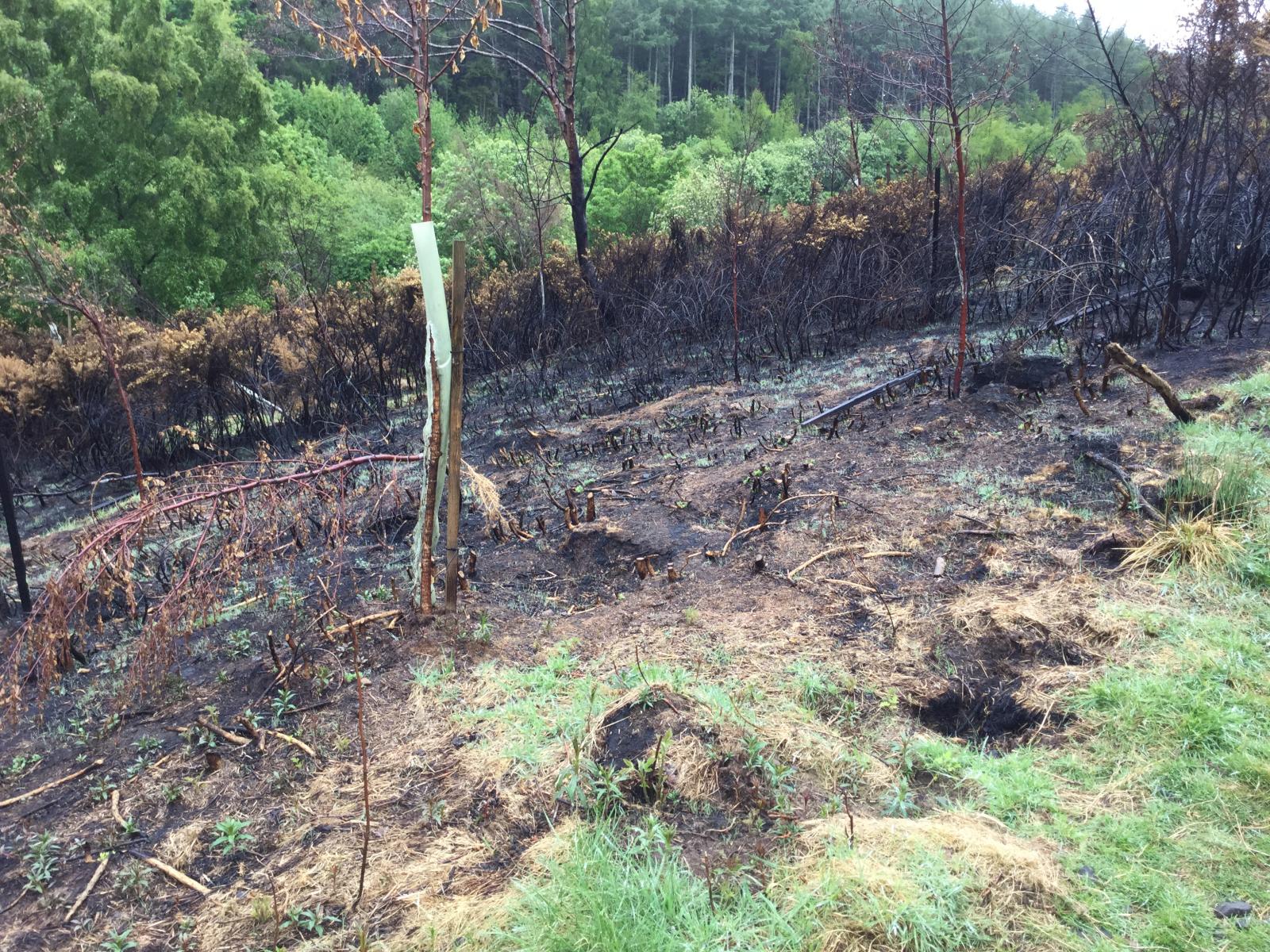
Fire crews were called to two large crop fires in Somerset on the weekend of 20th April as high winds spread accidental fires. Leaving 90% of the field and crops damaged by fire, this issue adds another struggle for UK farming, and further afield.
Scottish Fire & Rescue (SFRS) teams attended a fire on the Isle of Barra in April 2024 "involving an area of grass and gorse which is alight…Due to difficult terrain and darkness, crews will re-attend at first light tomorrow morning. Residents are advised to close windows and doors."
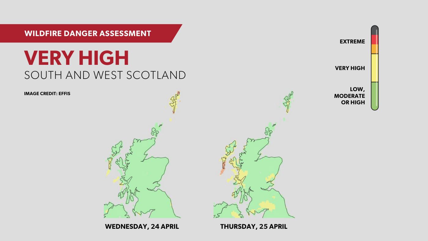
Western and other parts of Scotland saw a very high wildfire danger level in late April. The message in these areas is not to light a fire outdoors nor use a naked flame as "it can have devastating consequences." Group Commander Niall McLennan
“The key issues over the next few days are sunshine, warm air temperatures, low humidity and moderate to strong winds. During this period of high risk, fires could ignite easily, spread fast and burn with high intensity.”
As our global climate heats up, the warmer atmosphere holds more moisture and we see heavier and more frequent rainfall in the winter months. This results in flooding. However, there is also a shift to a warmer climate overall, so fewer cold episodes with more intense heatwaves and record-high temperatures. The heat can build more quickly and stay for longer as soil dries out and weather patterns get stuck. If rain does arrive, it can be torrential and sudden, leading to flash flooding which just streams away, not even soaking into the hard ground. Heatwaves bring extra strain on the water supply for crops, people and industry. The soil and vegetation dry out and this provides ready fuel for the wildfires.
Wildfires have always occurred but climate change is making the conditions more problematic. Heatwaves and droughts will become more extreme with water scarcity issues increasing. Fire-induced particles cause health concerns due to poor air quality but also change radiative fluxes; from incoming sunlight and heat escaping by night with a blanket of particulate matter and clouds. Greenhouse gas emissions increase and forests are lost in fires around the world.
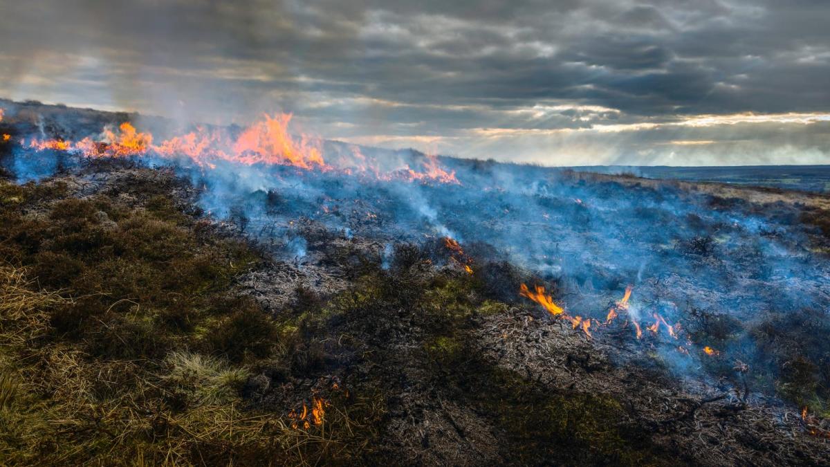
All of this is separate to the obvious danger and destruction that fires can cause. Often in the UK, they occur in more remote areas, on hillsides well inland or moorlands. However, this is not always the case or doesn’t end up that way as the wind blows the fires towards urban areas. As our climate changes, the population grows and housing areas spread, we should expect more wildfire incidents. Impacts in places such as Australia have been deaths of people, livestock and wildlife, burn and smoke inhalation injuries, heat stroke, homes razed, and physical trauma followed by grief and psychological consequences with ongoing mental illness. For the wider population, air pollution has a significant impact and is often more hidden.
“Accurate wildfire forecasting can inform regional management and mitigation strategies in advance of fire occurrence” Probability of Fire forecast (PoF)
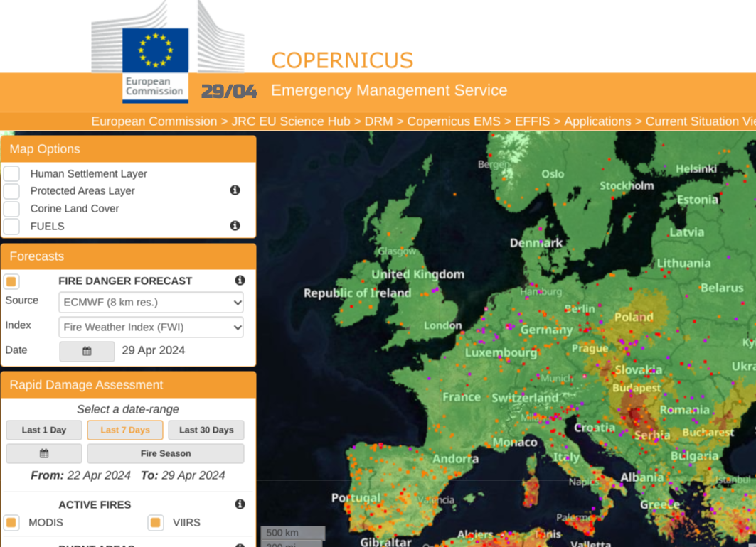
New layers have been added to weather forecast models in recent years. They are benefiting from AI and decades of satellite imagery. They tend to link weather conditions with fire activity to create an index of fire risk. The Met Office has the Fire Severity Index or FSI for England and Wales. There are the Wildfire Danger Assessments in Scotland “the areas across Scotland most likely to be affected…alert the public to the threat of wildfires” and from the European EFFIS (part of Copernicus Emergency Management Service) a Fire Danger forecast using a Fire Weather Index (FWI).
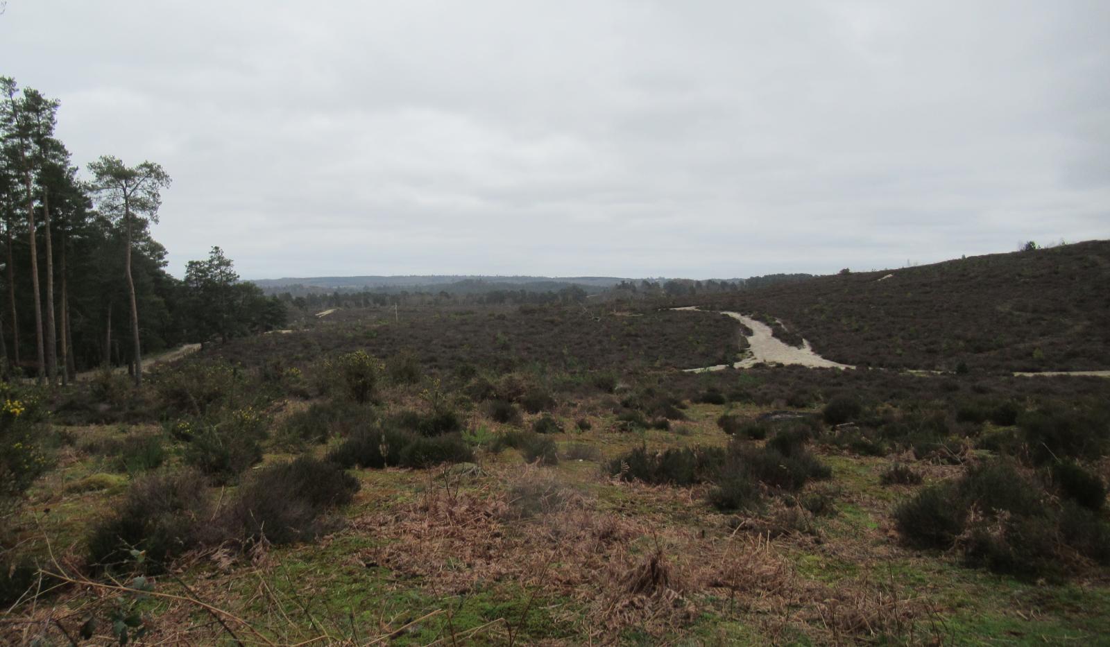
These forecasts mainly look at the upcoming weather to predict the dangers and threat in the coming days. The ground conditions are more tricky to gather and input. If the vegetation is dry and the forecast shows little rain, some warmth and a brisk wind then the risk increases. If a fire does start, then how quickly will it spread? This mostly relates to the wind and existing land conditions. Regions with heather, gorse, and peat are particularly susceptible to wildfires. Similar to weather modelling, the initial conditions, resolution and ground detail affect the output, whether urban, agricultural or moorland. It is a bit like lightning risk forecasting, it’s not that there is a high risk YOU will see a wildfire or be struck by lightning, it’s that the risk of an event in your area is higher due to a set of conditions in the coming days.
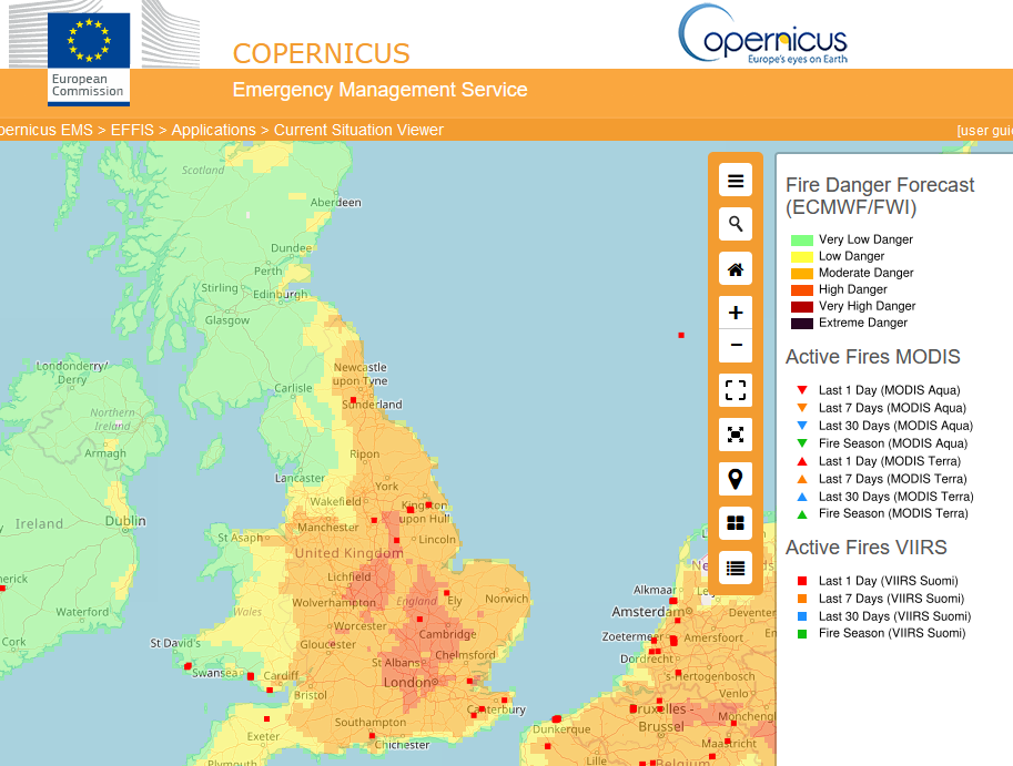
Fire Danger and Active Fires from 2021
ECMWF “All this is before we even consider the factors that might start a wildfire in the first place (known as ignitions). Ninety per cent of ignitions are caused by the unpredictable behaviour of humans, making them chaotic in nature and hard to predict.”
Many wildfires are sparked by human activities, including discarded cigarettes, campfires, out-of-control muirburn (deliberate burning) and even arson. Emergency responders will need good information to tackle blazes and the air quality will need monitoring. These events can last for weeks or even months.
Human actions increase the risk of wildfires so Fire & Rescue teams and Councils remind people annually to act safely and responsibly. This can significantly lower the chance of a wildfire starting. Heath scaring still exists from events in recent summers.
Experience on the ground means that firefighters and council responders know how local regions behave under certain conditions. Combining the ground conditions (vegetation type) with the weather forecast, AI can learn and improve the fire forecast. This computer 'experience' comes from previous fire heat data, historical satellite images, and recorded weather conditions such as wind direction. There are some issues, the Active Fires data is only gleaned once a day, so fires will be missed and at times, the cloud cover will be too thick for some fires to be recorded by the satellite.
The modelling will struggle with extremes as, by their very nature, they aren’t seen often or have never been recorded before. However, “a data-driven machine learning approach” can potentially strengthen forecast output as we live with a growing wildfire risk on a warming planet and hopefully save lives.
With warmer weather, droughts and heatwaves more wildfires are likely and they will encroach on urban life, just as we have seen in other parts of the world. The burning and smoke will hinder progress towards the UK’s climate and biodiversity goals as the damage costs rise and emergency responders are stretched further. Education and community engagement will help as "almost all UK wildfires are started by humans." (In other parts of the world, lightning strikes are a significant cause.) Longer term, there is a need to increase "the resilience of UK landscapes and habitats to wildfire", but there are differing opinions around land management practices. Wildfire risks to UK landscapes UK Parliament research
"Reducing the vulnerability of landscapes and habitats to wildfire would deliver environmental benefits including protection of biodiversity and carbon stores, whilst preserving productive rural landscapes and preventing damage to at-risk infrastructure and communities. "


.jpg?w=350)


.jpg?w=175)