Parts of central United States are amidst a multi-day outbreaks of severe thunderstorms which unleashed destructive tornadoes across parts of Nebraska and Iowa on Friday, with more severe storms and perhaps another tornado outbreaks expected over the central and southern Plains today.
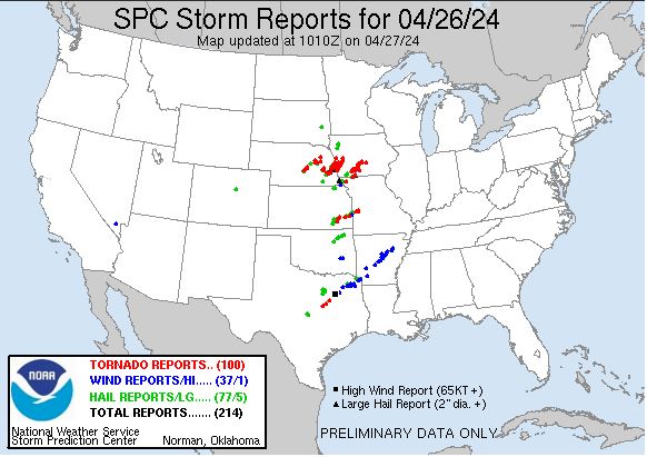
100 tornadoes were reported on Friday over 5 states in the central United States, mostly in Nebraska and Iowa, but also a few in Kansas, Oklahoma and Texas.
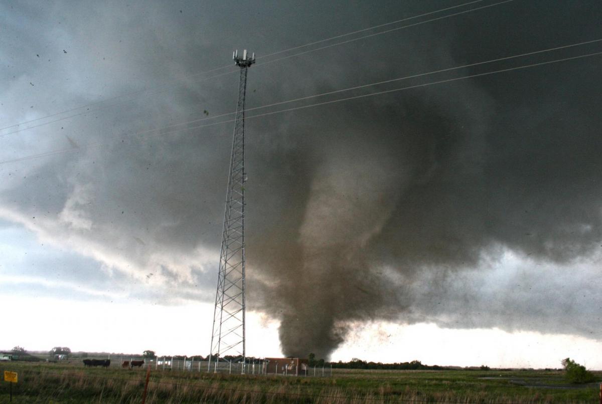
Some were long-tracked violent tornadoes that ploughed through communities in eastern Nebraska and far west of Iowa, causing destruction, including the suburbs of Omaha, a city with a population of around half a million people.
The first major powerful tornado to touch down was on the outskirts of the city of Lincoln, Nebraska, where a tornado tore the roofs off homes and crossed part of I-80 (interstate). Multiple train wagons were derailed near Waverly after it was struck by a tornado.
Drivers on the Interstate 80 near Lincoln, Nebraska watched in horror as a strong tornado crossed in front of them
Then not long after, further violent tornadoes touched down further north over Nebraska. The suburb of Elkhorn in Omaha, Nebraska, was one of the hardest-hit areas after a violent tornado ploughed through the community - flattening homes and businesses. Meanwhile in nearby western Iowa, a large tornado hit the small city of Minden, causing scenes of devastation of mangled structures and widespread debris.
Fortunately there have been no reports of deaths and even injuries were little, thanks to warning systems that were highly effective, with residents having plenty of warning, which saved lives. The National Weather Service issued at least four tornado emergencies, its most dire type of tornado alert, indicating an imminent threat of potentially catastrophic damage in a populated area.
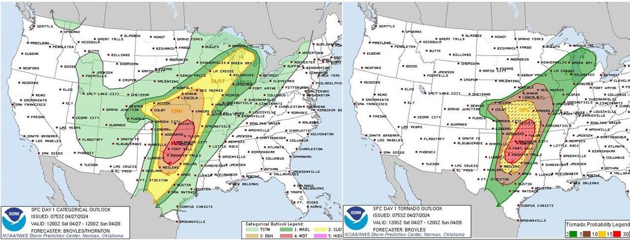
The focus for strong tornadoes looks to be further south than yesterday, with the eastern half of Kansas, much of Oklahoma and the north central area of Texas under a 10% or greater probability of EF2 - EF5 tornadoes within 25 miles of a point, rising to 15% over parts of northTexas, Oklahoma and the southwest of Kansas. Some strong wording from the Storm Prediction Center (SPC) “Several strong tornadoes will be likely, and a few long-track EF3+ tornadoes will be possible.”
Then on Sunday, further severe thunderstorms look to develop in swathe a little further east from northeast Texas into parts of the upper Mississippi Valley. Damaging winds, hail, and a few tornadoes will all be possible.
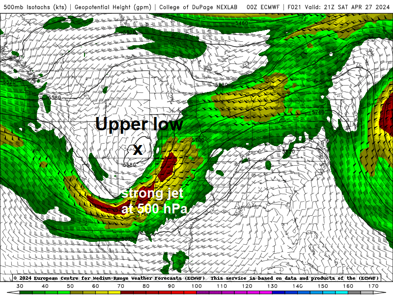
The severe thunderstorm outbreak that began mid-week over the southern and central Plains are part of a low pressure system across the central US driven by a slow-moving upper trough moving east across the western and into central states of the US - that is forecast to bring further severe weather over the weekend, including potentially strong tornadoes, to a vast region from the Texas border with Mexico into the Midwest on Saturday and Sunday.
Classic setup with the right ingredients for severe thunderstorms with tornadoes across central US this weekend
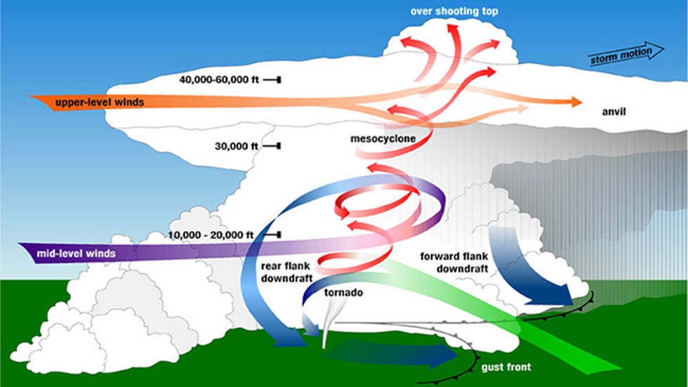
Certain ingredients combine to produce swarms of severe thunderstorms and tornadoes like the current setup over a central swathe of the United States. These ingredients can be most easily remembered using the acronym “SLIM” - Shear, Lift, Instability and Moisture.
Wind shear is a critical factor in the development and longevity of supercells. The classic setup for severe storms this weekend features a powerful jet stream rounding the base of an upper trough moving slowly in from the west, a strong southwesterly jet stream punching across the Plains above the south to southeasterly flow at the surface creates strong vertical shear. This strong wind shear allows a thunderstorm to tilt so that its downdraft doesn't choke off its updraft, allowing it to last longer than the ordinary thunderstorm. Wind shear may also produce a rotating updraft, which helps maintain the supercell's longevity and also enhance the risk of tornadoes forming should surface conditions become suitable.
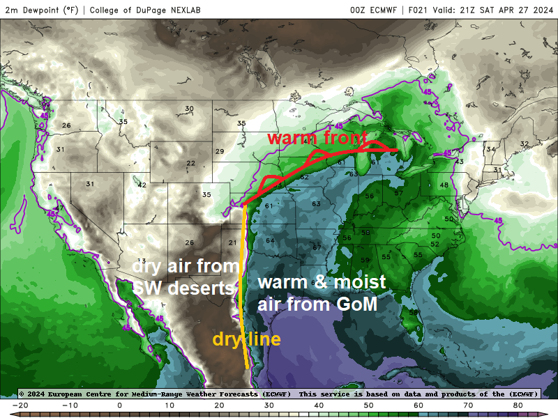
Warm and moist air in the lowest levels of the atmosphere is pulled into initially horizontally rotating air before becoming vertical and getting stretched, causing the rotation to increase.
If this change in winds and instability at the surface is extreme, as might occur near the warm front, dry line or low-pressure centre, tornadoes, perhaps strong, could develop within supercell thunderstorms.
The reason why the USA gets such strong and destructive tornadoes is down to large contrasts in airmasses, between warm and humid air drawn up from the Gulf of Mexico ahead of weather systems moving into the Plains from the west, dry air from the Desert Southwest and also cold air coming off the Rockies with these weather systems. These contrasts produce very strong instability, which when combined with a strong jet stream riding over the top can support such powerful long-lived supercell thunderstorms that not only can produce tornadoes, but can also drop hail the size of baseballs, produce winds up to and over 100mph, frequent cloud-to-ground lightning and unleash extreme rainfall that leads to flash-flooding.