Spells of rain or showers with sunshine in between affecting most areas today, snow over northern hills. Storm Nelson arrives tomorrow, bringing gales to southern coasts and windy elsewhere with further showers. Showers and wind easing somewhat into the Easter Weekend.
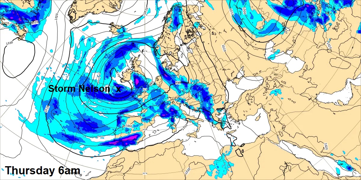
Low pressure is in charge for the rest of the week, which means further spells of rain or showers for many, with potential for some heavy downpours in places, there could also be some snow over northern and western hills. It will also turn increasingly windy on Thursday, as a deep area of low pressure, named Storm Nelson by the Spanish Met Service, moves northeast across western areas, gales possible across southern areas for a time. Remaining windy across England and Wales on Friday, but winds easing over the weekend, while showers will continue across southern areas, drier in the north.
Looking further ahead into early April and for those hoping for a respite from the seemingly endless rain since last summer, autumn, winter and spring so far have been exceptionally wet, then I’m afraid there is no sign of high pressure becoming established on the horizon. It looks like low pressure will stay in charge for the first 10 days of April at least, parked close to the west. Greatest chance of staying dry towards the southeast.
GEFS mean se-level pressure T+00 to T+384 (12th April) shows low pressure in charge throughout ...
.gif)
Back to this morning, a frontal zone with a band of rain has spread north from England and Wales across Scotland this morning, turning to snow over hills – as it bumps into colder air here. The rain has lingered overnight and into the morning across N. Ireland, with a Met Office Yellow Rain Warning in force here. The rain and hill snow over Scotland and N. Ireland will slowly clear north into the afternoon, followed by sunnier skies.
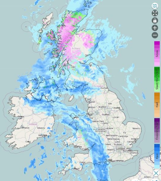
Further south, a sunnier start for many across England and Wales, however, a band of heavy rain, which fell as snow over the Moors of SW England and mountains of Wales earlier, will push north and east through the morning. Brighter skies but also a scattering of showery, locally heavy with hail and thunder possible, following across western areas of England and Wales, though eastern England could become mostly dry and sunny again. Temperatures reaching 7-9C across Scotland and N. Ireland, 9-12C across England and Wales.
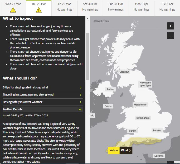
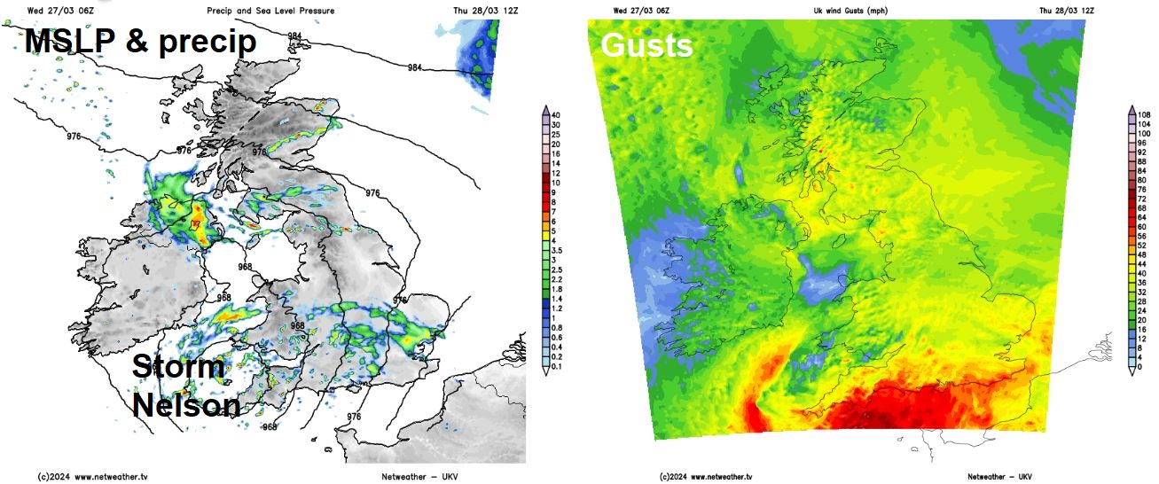
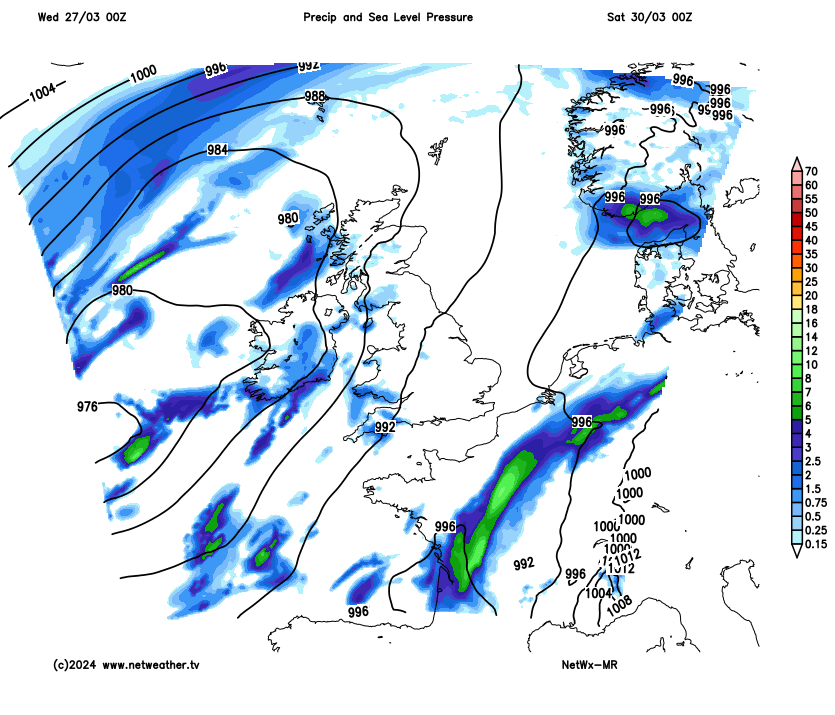
We then look to the west as Storm Nelson, spinning as a deep low south of Ireland to start the day, looks to then track northeast across western then northern areas of Britain through the day. The low will fill as it tracks northeast, but will have tight enough isobars on its southern flank, for a time, to bring gales or even severe gales around southern and southwestern coasts, with gusts of 50mph widely and perhaps gusts of 60-70mph along exposed southern coasts, while it will be windy elsewhere too. A Met Office yellow wind warning is in force between 7am and 6pm for the south coast.
The strong southerly or southeasterly winds will blow showers north and northwest across many areas, some of the showers heavy with hail, thunder and gusty winds. But also some sunshine between the showers. Temperatures reaching 9-12C.
Low pressure will be close by across the north and west on Good Friday, so expect further scattered showers, with hail and thunder in places. Isobars will be more tightly packed towards the southeast, slacker towards the north and west, so it will be windy across southern areas, though not as windy as Thursday. Temperatures reaching double figures across most areas, 11-13C, 8-9C in the far north.
Saturday and Easter Sunday will see low pressure ease further west, pulling a south to southeasterly flow across all parts, meaning it will be a little warmer, especially as there will be more in the way of sunshine. However, low pressure will be close enough to the west to mean there will be further showers breaking out in places, as the sun warms the air. Some of the showers heavy with hail and thunder. Some places, especially across eastern England, eastern and northern Scotland, could stay dry and sunny.
Some uncertainty by Easter Monday, which will keep weather forecasters on their toes, some models show outbreaks of rain spreading north, other models show a ridge of high pressure building – bringing mostly dry and bright conditions with light winds, though with a few showers in places.
Any fine conditions on Monday don’t look to last much further than Tuesday, as further areas of low pressure return from the southwest, bringing further wind, rain or showers for the rest of next week.
We’ve look hard for any signs of more settled weather lasting more than a day or two, but there is little sign of that over the next 15-16 days from model ensemble guidance. We’ve seen a wetter-than-average autumn then winter, spring, so far, seems to be following in a similar vein!