A cold feeling rather cloudy weekend with showery outbreaks of rain, sleet and hill snow but lengthy dry spells taking hold.
On Thursday, a low centre north of Scotland brought a cold blustery wind from the northwest even with bright spring sunshine. The cold front had reached SE Britain with more cloud and outbreaks of rain but that will clear away eastwards from Kent and Norfolk this evening. A scattering of rain, sleet and hill snow showers continue for western Britain with a clearer lull before midnight.
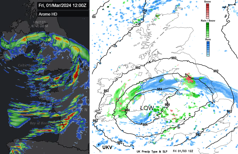
 A developing little low pressure is sliding in from the Atlantic and by midnight on Friday it will be to the southwest of Cornwall. The Inshore Waters forecast for southern coastlines mentions gales and severe gales. So a lively night to come with rough seas. This same low spins up over Wales and England on Friday and Saturday and dominates the weekend weather.
The Cumbrian Fells and Trossachs will see snow showers overnight in cold air for the north. Further south it will be windy. The main precipitation for early Friday will be from the low in the southwest. There will be icy rain for Belfast and Dublin with hill snow inland by dawn. A band of heavy rain will reach Pembrokeshire and southwest England just after midnight and there will be a spell of windy and very wet weather. There is a yellow heavy rain warning from the UK Met Office and flooding concerns after the recent wet weeks. This pivots over Wales and more of the West country before dawn. The main band could bring a wet commute to the Home Counties, snow over the Wehs mountains, the Peak District and wintry showers following in the clearance behind.
 Frontal band on Friday with a mix of rain, sleet and hill snow, with showers to the south.
The UKV model keeps most of the rain away from all but County Down and only brushes the south of the Isle of Man. Just be mindful that there could be some shift in this main band as it stretches west to east across Britain at lunchtime. To the north, frontal cloud then sunshine. To the south of the frontal band, there will be sunny spells and a rash of showers for Friday afternoon.

Frontal band pivoting westwards across Scotland with snow on Friday night
As the frontal band pushes up through northern England into SE Scotland there will be further blustery rain and snow, with the snow level lowering into the evening. This then reaches eastern Scotland overnight, again with some snow. Another small low centre is showing just to the north of Scotland with a tuck of vicious northerly winds and wintry showers brushing the coast
The low centre will have moved from the Irish Sea over southern Britain, with showery outbreaks pepping up during Friday night as the low swings up to The Wash early on Saturday. This will bring rain, sleet and snow in places. Away from the brisk cold north wind, there will be a widespread frost.

There will be areas of fine, nippy weather with bright sunshine but clusters of showers again with a mix of snow, sleet, hail and rain. Rain is more likely at lower levels in eastern Britain and snow more likely over high ground. There will be a good amount of cloud about on Saturday and it will feel cold with temperatures around 7 or 8C.
By Sunday, more of Britain will be drier but still with a fair amount of cloud. The northerly flow could bring further showery rain and hill snow to western Scotland, brushing Northern Ireland down to the Irish Sea. There will be an occluded band stretching from Scotland down to the south of France. This appears over the North Sea later on Sunday and might drift towards the east coast of Britain. It will feel cold again by day and as another frontal band approaches from the southwest on Sunday night it will come up against the cold air early on Monday. That could bring some travel issues for the Monday morning commute with heavy rain and maybe, snow in the mix.