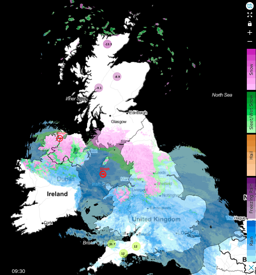
Parts of the North are seeing heavy, drifting snow today, especially over higher ground, with Amber warnings in force. Further South, heavy rain will be the disrupter.
Today brings a real taste of winter for some as rain, heavy in places and already across all but Scotland and the North East, turns to snow as it works its way steadily northward. As a result, various yellow Met Office warnings are currently in force, with amber warnings of snow and ice for parts of Shropshire, North Wales, the Peak District and the Pennines.
Across central and southern areas, precipitation will primarily be rain, some heavy, before it turns somewhat drier from the South and a little less cold. But later in the day, southern parts will see more heavy rain moving in. Across the higher parts of the North West Midlands, Northern Ireland and North Wales, we have snow, with the rain turning to snow over much of northern England, with the Peak District and the Pennines worst affected, where 20 to 25cms of snow is possible, that'll drift in strong North Easterly winds. This will cause travel problems, particularly on the higher parts of the M62, with road closures and possible power outages likely in these areas.
 Track the latest on the live radar here.
Further North, it's drier but colder and frosty, apart from a few snow showers in the far North. Temperatures were as low as -13C at Kimbrace in the Highlands first thing, with much of the day dry and bright over Scotland before snow moves into southern Scotland and the North East, where rain is more likely towards the coast. As winds freshen it'll feel particularly raw across the northern half of the country, where temperatures will struggle to reach 2 to 4C. But further south, it'll be much milder, with temperatures into double figures Celsius, 10 to 12C across southern England and the South West.
After dark outbreaks of heavy rain work their way slowly north across southern and later central parts, the rain becoming showery as it comes. But it'll be milder in a South or South Easterly breeze here as temperatures slowly rise across central parts. Across most of northern England, there'll be rain, sleet and snow, with any snow over Northern Ireland turning to rain. But more snow seems likely over the Pennines and Cumbrian Fells, with further drifting in a stiff northeasterly wind.
The far North of Scotland should continue mainly dry, but East Scotland turns increasingly unsettled. There'll be snow at times, giving a covering even at lower levels, with some heavier falls on hills, especially the Southern Uplands. Highland should see the driest weather with another frost, with the remaining parts of western and southern Scotland seeing snowfall overnight, causing problems especially on hills. Across much of the north, temperatures will be close to or only just above freezing, but in the South, it'll be much milder, with 7 to 10C near 'the mark' here.
During Friday, Scotland sees the bulk of the wintry weather, with disruptive heavy snow and blizzards for a while, before less cold air brings a thaw to the South. Milder air also brings a thaw to Northern Ireland and North England, where it'll sometimes be misty and wet. Elsewhere, expect showers, some heavy, but with temperatures in double figures again in the South.