Analysis of the risk of locally significant snowfall of higher ground of north Wales, N England and Scotland during Thursday and Friday. Also the risk of heavy rain and flooding in the south.
After a mild weekend and beginning to this week across most areas, particularly in the south, colder air has spread south behind a cold front that cleared the south coast this morning. The cold front has stalled and still lurks through the English Channel and into the far north of France. The frontal boundary will then move back north as a warm front tomorrow, as a low pressure system over the North Atlantic moves into the southwest approaches tonight.


The low pressure system is rather complex with multiple centres and sets of frontal systems and troughs that will drift north across the UK over the next 48 hours. The first of these fronts lurks just to the south of England this afternoon, this will lift back north as a warm front tonight and through Thursday. A band of rain will accompany this front, but as it bumps into the increasingly colder air from central areas northwards, it looks to turn to snow on its northern edge before turning back to rain from the south at lower levels. The rain, sleet and snow will be boosted by an occluded front moving from the south and taking over from the warm front.
 Snow risk moving north Thursday – Saturday over central and northern areas
There is potential for persistent moderate to heavy snowfall over higher ground of north Wales, Peak District and south Pennines, though models do differ on accumulations. GFS shows least accumulation but ECMWF and UKMET are showing 20-30cm locally across higher parts of North Wales and the southern Pennines. Hence why Met Office have issued an Amber Warning for snow in force between noon and 6pm tomorrow for snow in both these areas for the potential for up to 25cm above 200-300m.

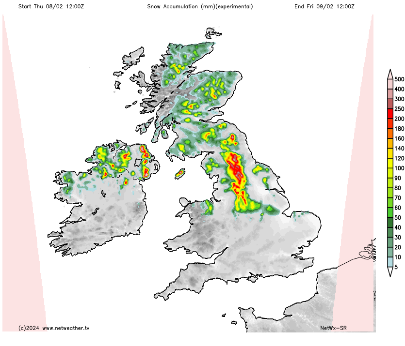
At lower levels, some accumulations are likely too, across North Wales, North Midlands and much of northern England – where the Met Office have issued a yellow warning for snow. They mention up to 2-5cm before thawing as snow turns back to rain, but above 200m there may be 5-10cm.
Eventually mild air will spread up from the south across central and northern areas of England and north Wales, with snow turning to rain with any snow thawing apart from over the highest ground.
.JPG)
Outbreaks of snow will continue to spread north across Scotland through the evening and overnight into Friday, as the frontal system continues north and pushes into the cold air receding north ahead of it. Snow turning to rain from the south across southern Scotland through the morning away from highest ground, but probably staying as snow north of the Central Belt across the Highlands of Scotland – where there could be some significant accumulations by the evening, when snow will turn to rain at lower levels before clearing away north. Warnings for snow and ice are in force for much of Scotland covering Friday and into Saturday until 6pm across Highlands and northern Scotland. 1-5cm at lower levels, 10-20cm over 300m.

Airmass characterised by unseasonably high wet-bulb potential temperature (theta-w) values looks to spread north across England and Wales during Thursday – hence the high snowfall totals for central and northern areas for a time. Highest theta-w values towards southern England during the evening – where they are forecast by GFS to reach 12C during the evening. This is indicative of high moisture content of the airmass. An upper shortwave trough and occluded frontal system swinging in from the southwest will likely create lift of this relatively warm and moist airmass – creating some heavy rainfall pushing into southern Britain during Thursday evening – which could lead to some localised flash-flooding following heavy rain earlier in the day moving north. A Met Office yellow warning for rain has been issued for southern areas and is in force between 2am Thursday and 6am Friday, with many areas seeing 15-25mm of rain, some higher ground areas of south Wales and southern England seeing 35-45mm.


Rain should ease to showers Friday, before turning drier Friday night and through Saturday away from Scotland which will see rain, sleet and snow spreading north before clearing north during Saturday morning. However, more rain may push north across England later on Saturday and overnight into Sunday, before clearing north across Scotland on Sunday – where it could bring further snow over higher ground.