Frontal rain from the south hitting cold Arctic air brings the risk of snow and disruption on Thursday and Friday. Frost and Ice in the north, localised flooding in the south.
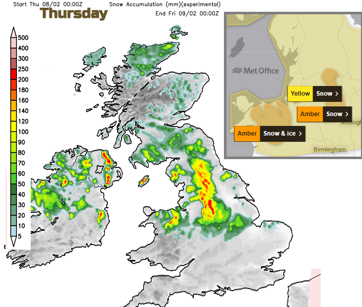
There is an Amber snow warning from the Met Office for Thursday over the "Peak District and south Pennines" with medium impacts likely from snow. It’s set within a wider picture of cold Arctic air from the north, mild air in the south and a frontal band of heavy rain turning to snow as it moves northwards and hits that Arctic air. There are other severe weather warnings, for Snow & Ice and Heavy Rain.
People on Orkney have woken to stunning snow scenes today as heavy showers moved across the islands in the small hours of Wednesday morning. With little wind, there was a thick white covering to behold as the curtains were drawn. Other parts of Scotland have seen smattering as a trough line trundled down from the northwest, followed by more heavy snow showers.
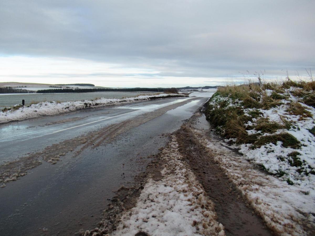
There was quite a divide overnight with cold Arctic air taking hold from the north, a band of frontal rain over southern Britain and some very mild air just clinging on for southern counties of England with temperatures around 11C. Overnight Scotland saw temperatures inland down below freezing, lower than -4C in the hills. Northern England and Northern Ireland hovered around zero at dawn and as the rainband reaches the English Channel on Wednesday morning temperatures over England and Wales are now in low single figures.
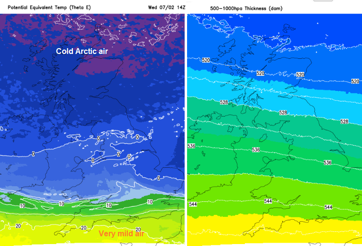
There are three key ingredients here for our UK weather over the next few days. The cold Arctic air, much milder air in the south and the frontal rain band in between will bring some snow.
The 528 DAM thickness line is just into Northumberland today, with the 516 line passing John O’Groats with the air reaching down from the Arctic. The frigid air will retreat northwards through Thursday with the 528 line ( a forecasting indicator, a rule of thumb for where you might expect precipitation to fall as snow in the UK) closer to the far north of Scotland.
The frontal rain band which has sunk south overnight will return northwards on Thursday as an occluding warm front. It’s been a complicated setup and we have seen the Met Office early yellow warning snow area shift about a bit, which is down to changes along this frontal system.

You have to think about which zone you will be in. Generally, southwest England stays in the very mild air, with mild conditions for southern Wales and southern counties of England. Rain will set in for SW Britain during Wednesday night and be across much of southern England as well for rush hour on Thursday. This band heads northwards and there will be a cloudy, mild lull and then another band of rain pushes up from the English Channel for Thursday teatime. This will include heavy bursts and tricky conditions on the roads with poor visibility and spray
“Local river and surface water flooding is possible across parts of the Midlands and the South of England on Thursday,” and additionally “Yorkshire and the Humber, and North East England on Friday.” EA

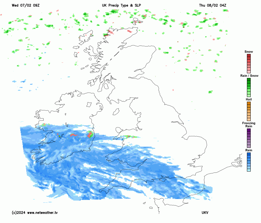
Netweather Radar Thursday 8th 09:10
To the north, there will be cold nights and chilly air by day but fine winter sunshine on Wednesday. The scattered snow showers continue on Wednesday with only a few left by tomorrow. The Islands and NW Highlands have an ongoing yellow warning for Snow & Ice. Northern Scotland could see temperatures down to -10C tonight. High frontal cloud will reach northwards by Thursday although it will still be sunny and frosty for northern Scotland. A few snow showers will edge in from the northeast on Thursday evening. By Friday morning, there will be cloud right across the UK.
 The wet or wintry mix
The low centre will stall off western Ireland and its frontal boundary across mainland Europe and out west into the Atlantic. For the UK, the first warm front will move up from the southwest early on Thursday, soon turning to snow across the high ground in north Wales. The Met Office have pinpointed medium impacts from this snow are more likely around the Peak District and south Pennines region with an Amber snow warning for Thursday. There is a yellow warning over northern Wales, the Midlands and northern England but that doesn't mean that other areas are immune. This wide band of precipitation is hitting the cold air and along it will be rain, sleet and snow. Snow is most likely over the high ground on the leading edge but don’t hang onto fine detail from weather apps. Think about the overall picture if you have to travel. Prepare and try to adapt as travel conditions will be difficult. The UKV model has sleet and snow setting in across a central swathe of Britain through lunchtime and edging up into Northern Ireland and the Lake district through Thursday afternoon. Northern Ireland has a warning for rain, sleet and snow with ice on Thursday and overnight into Friday morning.

Another small low pressure will move up from the Bay of Biscay later on Thursday and give a kind of bumper-car shove to the existing frontal band. So we have more rain over England, a cold easterly flow over northern Britain bringing in a few snow showers off the North Sea. The frontal precipitation is still a mess, a mix of rain, sleet and hill snow as it edges into more of northern England, Northern Ireland and southern Scotland.

Northeastern England, down to north Lincolnshire could see miserable conditions on Friday as the flow pushes more rain, sleet and snow in from the east. Snow accumulations for the eastern side of the Pennines could tot up on Friday. There could be travel disruption and ice but again expect some movement in the areas worst affected.
Other models push the precipitation further north on Thursday, with northern England, Northern Ireland and southern, then eastern Scotland (by Friday) bearing the brunt of the frontal sleet and snow. Keep an eye on the Netweather Radar and be prepared for delays if you are travelling.