A look at the ongoing barrage of atmospheric rivers bringing flooding rains and deep snowfall to the mountains in California that started in late December. More rain on the way this week as more storms hit the drenched state.
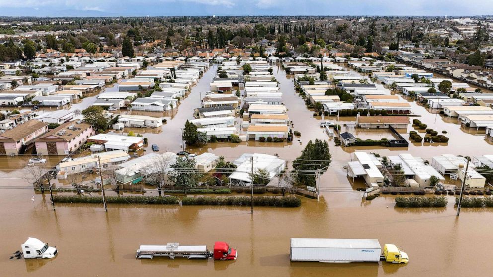
A new atmospheric river arrived across California last week - bringing significant flooding, especially in central and northern parts of the state, with another series of strong Pacific storms battering the region and piling more snow at higher elevations on to an already historic snowpack. Heavy with snow, roofs caved in over homes and grocery stores in mountain towns. The latest storm left more than 300,000 customers without power this last week.
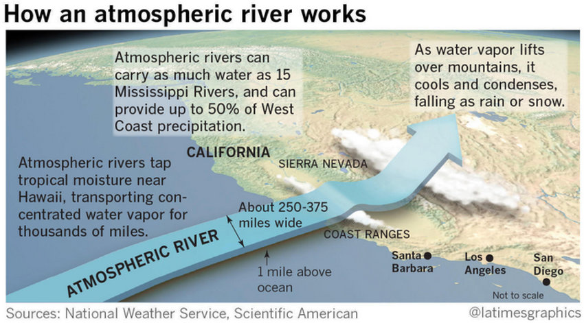
Atmospheric Rivers are ribbons or conveyors of very moisture laden air that extend out of the tropics eastward to the Western United States. They can be 300 miles wide and thousands of miles long, the moisture-laden streams can carry many times the volume of water of the Mississippi River. When these rivers in the sky collide with the West Coast and mountains inland, they condense into large amounts of rain and snow. Because the atmospheric rivers originate in Pacific tropic areas such as Hawaii, meteorologists dub them “the Pineapple Express”.
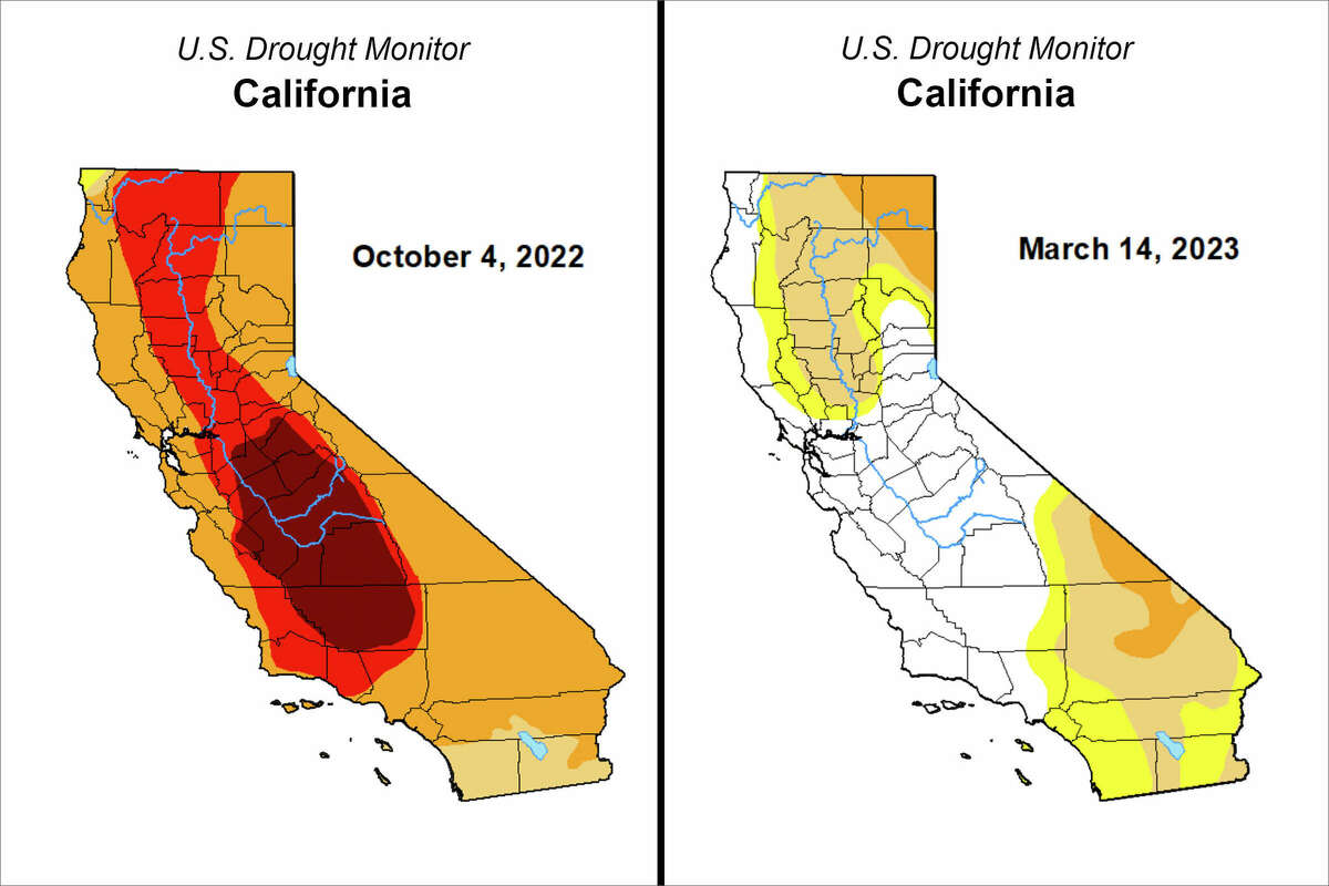
An abnormally wet winter, combined with further storms so far this month, has wiped out exceptional and extreme drought in California for the first time since 2020, but the very wet conditions the state has experienced over the last few months has come at a cost to those living near watercourses or in the mountains.
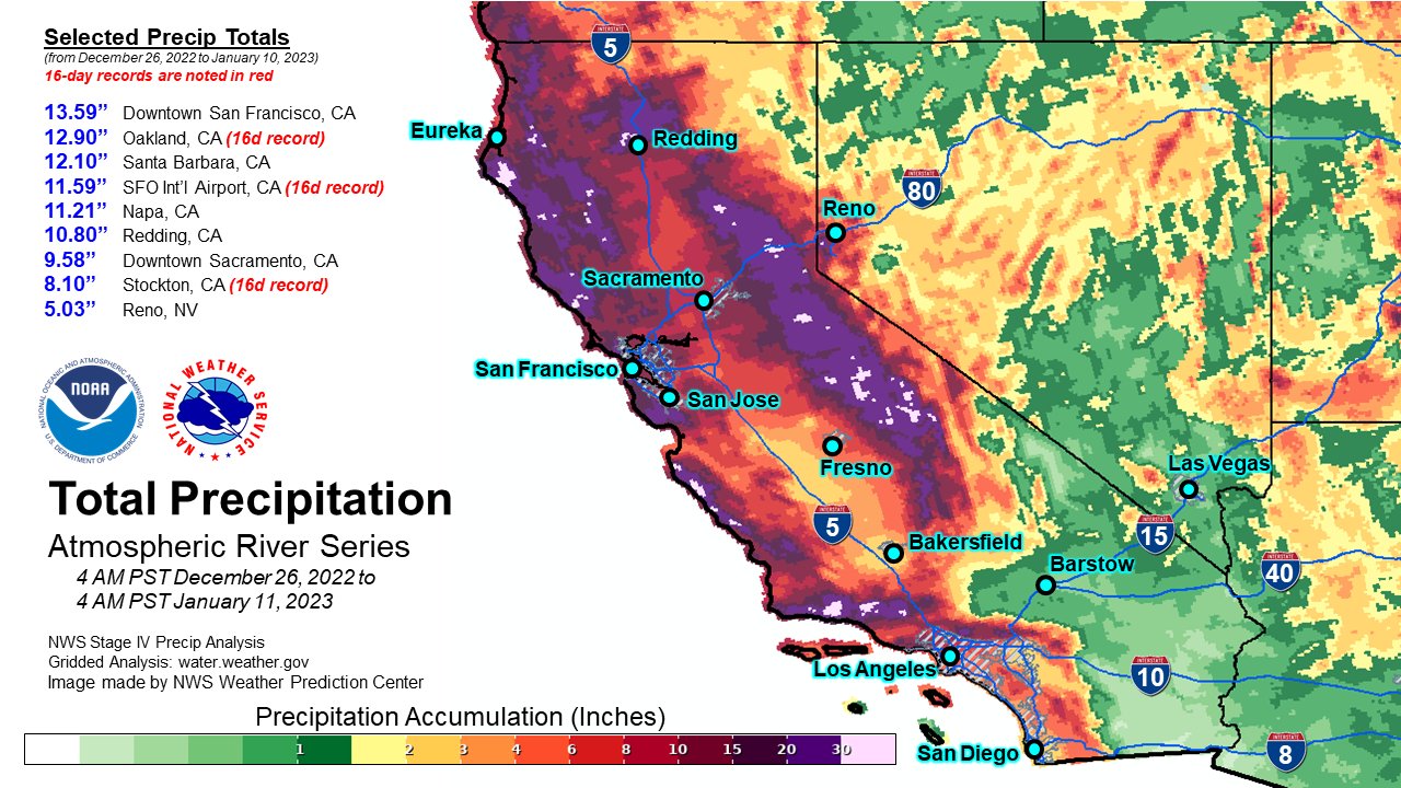
Starting on December 26, 2022, a series of 9 atmospheric rivers (ARs) brought significant amounts of rain, snow, and wind to California and other parts of the western United States over a 3-week period lasting until January 17, 2023. 80% of a full seasonal snowpack was deposited in California during these storms. Precipitation over these 3 weeks was 11.2 inches, which is 46% of a full water year. The storms brought widespread flooding and landslides to nearly the entire state of California. A Presidential Major Disaster Declaration was put into effect in 41 out of California’s 58 counties. Over 96,000 residents were evacuated, 500,000 homes and businesses were left without power. The San Francisco Bay area experienced its wettest three-week period in 161 years—the last time rainfall totals there were greater.
The parade of storms caused significant flooding in areas of the Central Valley, Salinas Valley, and Santa Cruz Mountains, along with power outages and mudslides. The deluge resulted in at least 22 deaths and prompted more than 1,400 rescues throughout the state. Another Atmospheric River slammed parts of California in late February, bringing further heavy flooding to Los Angeles County and whiteouts at higher elevations.
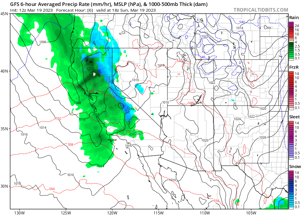
A further two back-to-back ARs this month so far have brought more heavy rain and snow, with flooding and avalanches in California over past week or so. And there’s not much of a respite for the state, as a new atmospheric river is taking aim over the coming week, the 12th so far this season, with another pair of storms which will once again threaten flooding to the already drenched state over the coming few days.
According to the National Oceanic and Atmospheric Administration (NOAA), unusually heavy precipitation in California this winter has helped ease drought conditions. Much of the state is no longer in a drought, according to a March 16 assessment from the U.S. Drought Monitor. Moderate to exceptional drought coverage across the U.S. is at its lowest since August 2020.
"Climate change is driving both wet and dry extremes," NOAA Administrator Rick Spinrad said in a statement. A warmer climate has intensified California’s “weather whiplash,” the rapid swings between dry and wet spells, leading to both longer, more intense droughts and stronger storms. Because warmer air can carry more moisture, atmospheric rivers will be able to deliver larger amounts of rain and snow.
This winter, record amounts of snow have blanketed California’s Sierra Nevada, leaving some local residents stranded on the roads and in their homes. Average snowpack levels statewide were more than three times as high this week as they were at the same time in each of the last three years. Snowpack is a crucial for California’s water supply. Rains recharge the state’s reservoirs in winter, but snow melt helps preserve their levels in the spring and summer, typically providing about 30 percent of the water supply for the state.
However, there is a risk that unusually warm temperatures in the spring and summer thanks to climate change could bring an earlier thaw season and more rapid melting – which could bring a heightened potential for spring floods.
Also, California may have missed an opportunity to capture floodwaters and replenish underground aquifers. The state’s aquifers can hold vastly more water than all of the major reservoirs combined, but they have been depleted by decades of heavy pumping, especially in agricultural regions like the Central Valley.
So, drought relief for now, but drought is always around the corner in California, extreme drought like the last few years an increasing threat with climate change. So when the rains fall, the state really needs to find ways to capture as much of the rainfall as it can.