


High pressure to the south of the UK keeps the weather steady and calm but with fog forming overnight. In the far north, the ongoing windy weather peaks midweek and it feels chilly in that breeze.
High pressure to start the week has brought a lot of settled, fine weather with light winds. On Sunday, with the high centred over the UK, over 1048hPa was recorded which is very high but not record-breaking. Close to the centre of the high, there are only very light winds or no breeze at all. This allows fog to form and, depending on the cloud cover, temperatures can fall away by night and it turns frosty.
Winter high pressures can bring glorious blue skies and sunshine, which feels warm and gives a hint of spring. Or low cloud becomes trapped in the slowly descending air mass which little wind to disperse it. ‘Anticyclonic Gloom’ refers to a grey sheet of Stratocumulus which can linger for days around high pressure and make the days feel cold and almost depressing.
At the edge of a high pressure, it is a different story. Northwest Scotland saw blustery winds, more cloud and patchy light rain for Monday morning. There is already an early heads-up Yellow Wind warning for Wednesday over the far NW of Scotland. This mentions strong south/SW winds with the risk of “travel disruption and dangerous coastal conditions” with severe gales possible.
This week there will be pushing and shoving from these two different areas of weather. The settled, dry, often fine weather under the high pressure in the south and windy weather with frontal cloud from the north.
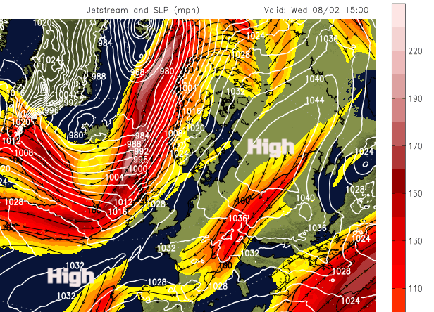
A Powerful Jetstream will be to the north to start the week, then sink over Scotland later on Wednesday. Stormy weather will edge closer. The high pressure from the Atlantic slides our way Friday into Saturday as the jet moves away to the north. This will settle the weather over southern Britain once again with fog reappearing.
Tuesday starts off nippy with fog in places for England and Wales and hardly any breeze. Southern Scotland and around the Irish Sea will have a cool light SW wind ahead of the fading cold front. This will bring more cloud and patchy rain to northern and western Scotland and to Northern Ireland on Tuesday morning. It then fades and stalls over southern Scotland and County Down where temperatures will stay at around 7C well into the evening.
Southern Britain again has a quiet night with fog forming and very light southerly winds.
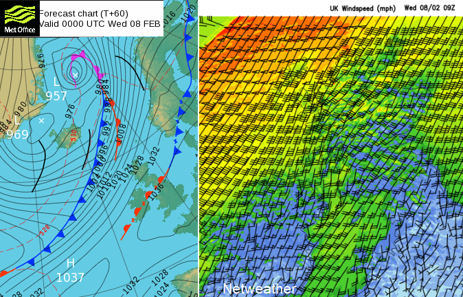
The gusty winds pick up through Wednesday morning, over Scotland, northern England and Northern Ireland. There are concerns about possible stormy weather affecting the Hebrides, The Minch and NW coast of Scotland, on an increasingly windy day for northern Britain.
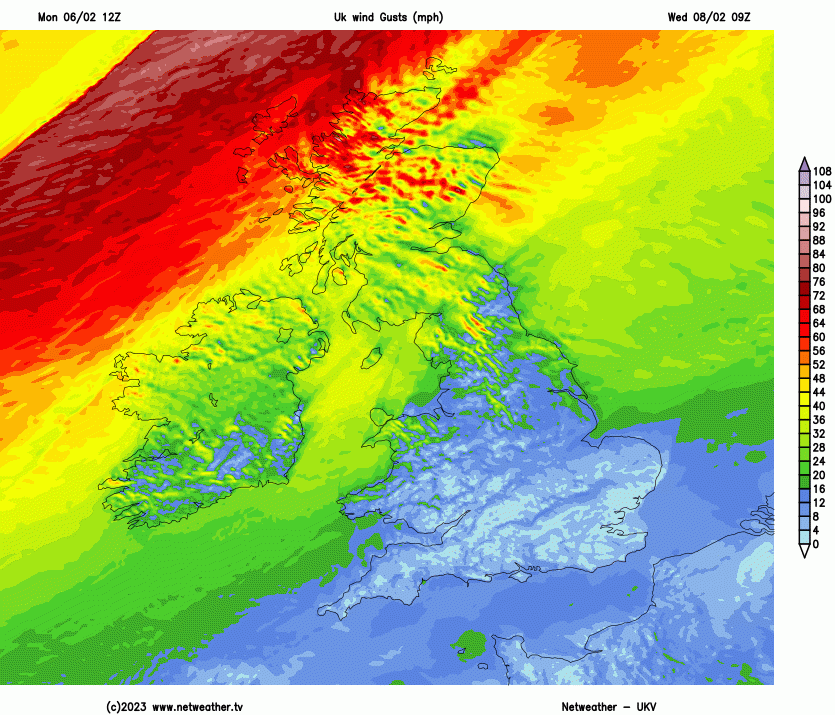
As the strong gusty winds, with gales for exposed parts, move eastwards, the frontal band of rain will arrive through Wednesday afternoon. Behind this will be colder air so there will be hill snow on the back edge and wintry showers following on behind for northern Scotland on Wednesday night.
Wednesday evening rush hour could be affected by strong gusty winds over Grampian, through the Central Belt, southern Scotland and the far north of England, particularly over Pennine routes. This wild weather eases but there will be another (lesser) bout of strong winds from the west whizzing across northern Scotland on Thursday.

This pattern just continues, windy in the far north but calm in the far south. The risk of fog forming overnight for southern Britain but fine weather by day although there will be more cloud about later this week.


